Saturday, November 17, 2018

Serra da Capivara National Park - Piauí State

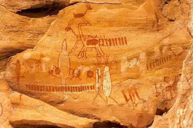
Many of the numerous rock shelters in the Serra da Capivara National Park are decorated with cave paintings, some more than 25,000 years old. They are an outstanding testimony to one of the oldest human communities of South America.
Photo: site ICMBio

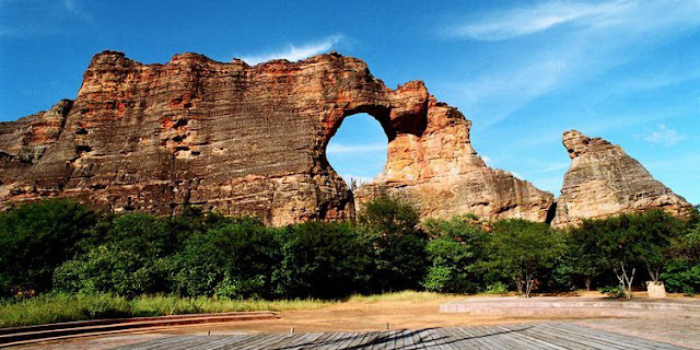
The Park covers nearly 129, 140 hectares and has a circumference of 214 kilometres. It is situated in the morphoclimatic zone of the Brazilian Caatinga, distinguished by the multiplicity of plant formations typical of the semi-arid regions of Northeast Brazil. The region’s plant species are primarily characterized by the loss of most of their leaves during the dry season, extending from May to December, serving to lend the landscape its silver hue. The region borders two major geological formations – the Maranhão-Piauí sediment basin and the peripheral depression of the São Francisco River – and is endowed with a diversity of relief vegetation and landscapes of breathtaking beauty and dotted with exceptional vistas of the surrounding valleys, mountains, and plains.

The area houses one of the most important archaeological sites in the Americas containing evidence and artefacts that have forced a sweeping re-evaluation of the fundamental traditional theories underpinning the origins of human settlement in the Americas.

Over 300 archaeological sites have been found within the park, the majority consisting of rock and wall paintings dating from 50,000-30,000 years Before Present. Many of the numerous rock shelters in the Serra da Capivara National Park are decorated with rock paintings, some more than 25,000 years old. The analyses and dating of the evidence and artefacts found in the Serra da Capivara National Park serve to confirm the millennial presence of human beings on the American continent and the importance of the heritage. (source: unesco). It became a World Heritage Site in 1991. Its head archaeologist is Niède Guidon. Its best known archaeological site is Pedra Furada.

WHEN TO GO

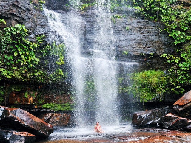
In any season one can visit the Serra da Capivara National Park. The landscapes of the rainy season (locally called "winter") and dry season (locally called "summer") provide different experiences of environmental colors and the flora and fauna adaptations to life in the Caatinga. From January to July the weather is mild and the vegetation has leaves and flowers, providing a more shaded area for hiking. After the rains, one can observe temporary waterfalls along the escarpment. In May and June the vegetation gets red, yellow and brown hues announcing the loss of leaves. From August to November is the hottest time of the year and most of the vegetation has no leaves.

GETTING AROUND

The park administration is headquartered in São Raimundo Nonato/PI, which is 26 km far from the access to Guardhouse Boqueirão da Pedra Furada and 19 km from the access to Guardhouse Serra Vermelha, both in the National Park's boundaries.

ACCESS:

The best way to get to Serra da Capivara National Park is to go by plane to Petrolina/PE, and from there go about 300km to São Raimundo Nonato. The airport of Sao Raimundo Nonato is under construction, but the aistrip already receives small aircraft.

There is currently no public transportation from São Raimundo Nonato or Coronel José Dias to the park's entrances.

Source: bnbparks
Photos: Google


Tamanduá, photo André Pessoa


Friday, October 26, 2018

Sete Cidades National Park - Piauí State


The park contains arid savanna forest (babassu forests] and areas of contact between savanna, arid savanna, and seasonal forest. It protects an important geological formation and conserves water resources in a dry region. The geological monuments are the main attraction. The park also has some pre-historic cave paintings and inscriptions.

Beauty of millions of years!


Sete Cidades ('Seven Cities') National Park contains seven rock outcrops, called cidades (cities). A 12km walk will get you around.

Visitors are encouraged to see the National Park in a very Brazilian way. There is little information about the geological evolution or structure of the rock formations. Visitors are invited to use their imagination to decide what the rocks might resemble.

The Sete Cidades National Park (Seven Cities), established in 1961, is located in the northeast part of Piauí state, in the municipalities of Piracuruca and Brasileira. The Park covers an area of 6,221.48 hectares, where most of the found flora is typical of cerrado with caatinga spots. Throughout the course of the rivers and springs there are forest spots and aquatic plants living in natural pools and lakes, also beautiful waterfalls.


The site hosts rock formations of about 190 million years old and rich rock inscriptions. The park gets its name because of the different rock groups that seem to form small "cities", exciting visitor's imagination. (search: bnparks).

When to go: The climate is tropical, with average annual temperatures between 25°C. The best time to visit the park is from January to June, when the waterfalls are fuller. The driest season is from June to December.

The city of Piripiri, where the Park's headquarters is located, can be reached by two state capitals:

Teresina, Piaui's capital, lies 165 km from Piripiri through BR-343 highway. Arriving at Posto Petecas, in Piripiri-PI, go straight to the BR-222 highway for 10 km and turn left to the Park's entrance at the km nº 64. 

Fortaleza, Ceará's capital, lies 410 km from km nº 64 through BR-222 highway.


See more setecidades


Monday, April 16, 2018

Fruits of Brazil: Jambo

The fruit that Brazilian call the jambo (botanical name Syzygium jambos) has many names in English. Depending on the region, it is known as Malabar plum, plum rose, water apple, jambrosade, rose apple or Malay plum. The names Malabar plum and Malay plum indicate the fruit's original habitat - the tropical zones of South and Southeast Asia. The fruit was carried from Asia back to Portugal by early Portuguese navigators, and thence onward to Brazil, where it flourishes in the tropical regions of the country.

There are many varieties of jambo, but the three most commonly seen in Brazil are distinguished by their color - jambo vermelho (red jambo), which is a dark winy reddish-purple, jambo branco (white jambo) which is an icy, glossy white, and jambo rosa (pink jambo), which is light rosy pink in color.
white jambo

red jambo flower

Red jambo

Pink jambo
The fruit of jambo is smallish, about the size of a child's fist, and slightly elongated - either pear-shaped or bell-shaped. The skin is waxy and thin, and the hollow core of the fruit contains one or two seeds. The flesh is white and is crispy and juicy like an apple. The fruit isn't highly flavored, though it is sweet. It is very aromatic, and the similarity of the fruit's aroma to roses accounts for such English names as plum rose or rose apple.

Jambo isn't highly commercialized, and is usually only seen in markets in areas where the fruit is cultivated. Most of the fruits consumed are eaten fresh, although jambo can be successfully preserved in syrup or made into a compote.
(source :flavorsofbrazil)

Saturday, March 24, 2018

Teresina,the Green City


Teresina is the capital and most populous municipality in the Brazilian state of Piauí, a city in northeastern, at the confluence of the Parnaíba and Poti Rivers. It's the only capital in the Brazilian Northeast that is not located on the shores of the Atlantic Ocean. Teresina is generally a degree or two hotter than neighbouring state capitals.

If you are just passing through, take a stroll down Frei Serafim, the main street, to the Igreja São Benedito (if it is open). Have a glass of fresh sugar cane juice, washed down with a pastel, in one of the small launchenettes, then walk across Praça Pedro II to the excellent Central de Artesanato to buy some traditional craftwork, before heading off to eat some meat or the excellent local crabs. 

Avenida Frei Serafim (Canteiro central)

Like Manaus in Amazonia, Teresina has its own "Meeting of the Waters", although the Parnaiba and Poti rivers are not on the same scale!

Teresina was Brazil's first planned city, with streets in the centre on a grid, before anyone had even thought of building Brasilia. It is known as the Green City on account of the mango trees lining so many of the major streets. It is one of the safest state capitals in Brazil.

Every June, Teresina hosts Brazil's national folklore festival (the Encontro Nacional de Folguedos) in the Park Potycabana. There is dance, music, culture and food from all over the country.

There isn't much to see in Teresina...but there are some sightseeing interesting:

Palácio de Karnak


It is in Greco-Roman style, with gardens designed by landscape architect Roberto Burle Marx, best-known landscape designer, in 1970. The palm trees are carnauba, whose wax is one of the state's most valuable exports

This pleasant neo-classical structure has been the official seat of the Governor of Piauí since 1926 and contains some works of art and antiques. For unknown reasons it is named after the Karnak at Luxor in Egypt, and local people seem to think the architecture is Egyptian. It is alleged that in the late '80s, the outgoing governor made a quick exit, together with many of the valuable contents. 

Nearby, the Master Dezinho Crafts Center market has stalls selling goods from around Piauí state.
 
Praça Pedro II: This pleasant green square is in the city centre. Several major buildings are here including the Central de Artesanato, the Theatro 4 de Setembro and the Clube dos Diários.


The Theatro 4 de Setembro is the large neo-classical flesh coloured building with Islamic influenced windows.


The Meeting of the Rivers


The small Parque Municipal do Encontro dos Rios is located in the north of the city. Here the blue waters of the Poti flow into the Parnaíba river. There is a statue of Cabeça de Cuia here ( "Bowl Head"). The legend is that a young man, Crispim, lived with his mother by the river. They were poor, and dinner was a thin soup with a bone in it. Enraged, Crispim threw the bone at his mother, killing her. Before she died she cursed him, that his head would swell up to the size of a bowl. He would not be released from the curse until he had sex with seven virgins called Maria (this is Brazil...).


There is a floating restaurant here. There is also a little ferry, so you can go experience the meeting of the waters from the water.

If you are driving up along the side of the Poty you will pass a number of small-scale pottery manufacturers. The area has the grandiose title of the Pólo Cerâmico Artesanal do Poty Velho.

At some points on the river you can see fishermen casting their nets from small canoes and women washing their clothes on the river banks.

Fossil Forest


Teresina's Fossil Forest (Floresta Fóssil) dates from the Permian period, 240 million years ago. Fossilised remains of trees are extremely rare. The forest was discovered in 1909. The most significant remains are now protected as the Parque Ambiental Floresta Fóssil, situated on the bank of the Poti river just 500 metres from Teresina Shopping. Unfortunately the authorities are not making sufficient efforts to preserve the remains, so their long-term prospects are in jeopardy.

Praça da Bandeira

A large green area in the city centre. The Museu do Piauí, Teresina's old market, the town hall and Igreja Matriz are all located here.


Ponte Metálica

The Ponte Metálica, the metal bridge connecting Teresina with the town of Timon in Maranhão is a local landmark and seen as a symbol of the city. It is, though, just a metal bridge.... It's proper name is Ponte João Luis Ferreira.


Ponte Estaiada:

The new bridge, Ponte João Isidoro, was opened in 2010. To the people of Teresina, and maybe the state, it represents their entering modernity. It is likely to become the new postcard image of Teresina.

It's a nice enough bridge, and has a viewing platform with capacity for 100 visitors at 95 metres above ground level. The viewing platform is served by two lifts. The bridge's main column is illuminated by blue spotlights at night.The view of the city is great, it's a 360 degrees view, which shows the whole beauty of the city.


Gelato & Grano: one of the best restaurante and ice cream place in Teresina with nice accents.


Mercado Troca-Troca

Troca-troca means "barter" in Portuguese. Actually, it is also slang for something else, but this is not a proper place to say it... 
Troca-troca a place to exchange your kitchen sink for an old bicycle rather than buy a memento of Brazil. The market started under the vast fig tree that now stands behind the permanent roofing, on the banks of the River Parnaíba. I include it here because it seems to be in all the guidebooks. Not really worth a visit, and the few tourist places in Teresina I would suggest going with a local friend.


O mais novo parque

Parque Estação da Cidadania


Wednesday, January 31, 2018

Piauí State

Sete Cidades National Park - Photo: sitesgoogle
The state of Piauí is almost completely situated in the Parnaíba Basin. The northern part of the state is low and marshy, while the south (which is inland) gradually becomes a high plateau. The main rivers and waterways that feed this plateau include the Poti, the Longa, and the Canindé. Between river valleys are flat-topped highlands called chapadas. The marshy areas of the south are low in nutrients, yielding low evergreen forests that can handle such compromised conditions. 

Piauí has the shortest coastline of any coastal Brazilian state at 66 km (41 mi), and the capital, Teresina, is the only state capital in the northeast to be located inland. The reason for this is, unlike the rest of the area, Piauí was first colonized inland and slowly expanded towards the ocean, rather than the other way around. 

In terms of its economy, Piauí is one of the poorest states in the country. The services sector, industrial sector and agricultural sector makes up the state’s major GDP contributions in descending order.

Its exports play a major role in the economy, and include essential oils, soybeans, cotton, cashew nuts, certain seafood and leather.

A need to concentrate on tourism has been identified in an effort to attract visitors to the country, which is so rich in cultural and historical heritage.

The state has many notable archaeological sites, including Serra de Capivara National Park and Sete Cidades National Park, which are rich in remains of prehistoric Paleo-Indian and sedentary-based Indigenous Brazilian complex cultures. the National Park of Serra da Capivara is a UNESCO World Heritage Site. The park has more than 400 archaeological sites and the largest concentration of rock paintings in the world, in a landscape dominated by canyons and caatinga.

The state of Piauí (pronounced Pea-ow-ee) is one of Brazil's best-kept secrets. It is difficult to get there, but the visitor is rewarded with perhaps the most untouristed place they will ever see. Piauí is the only Brazilian state to have three National Parks, and it borders two more. 

Piauí suffers an image problem in Brazil. It is seen as the stereotypical hot, poor northeastern state. Many guidebooks are infected with this prejudice. The good news is that this keeps the tourist hordes away. Piauí is the traditional Brazil. A land of cowboys, religious pilgrimages and unspoilt nature. The state is poor, but the crime rate here is a fraction of that in Sao Paulo and Rio de Janeiro. Most people have never spoken to a foreigner.

The early Portuguese settlers refered to Piauí as "Beyond Nowhere". A 1760 map of "Piauhy" by Henriques Antonio Gallucio reports much of the state as being "land which hasn't yet been explored". This was about two hundred and fifty years after Portuguese colonization. Famously, the Brazilian government once omitted the state from the official national map. It is a place for travellers, not tourists.

The northern coast has a large river deltas, a haven for birds and manatees. This coastline is starting to be discovered by kiteboarders and surfers. The National Parks - home of jaguars, anteaters and giant armadillos - contain incredible cave paintings and perhaps the earliest evidence of human habitation in the Americas. Cashew nuts are believed to originate in Piauí, and even today the state is a massive producer.

Parnaiba river. Photo: wikipedia

Pedra Furada, Serra da Capivara. Photo wikipedia